Progress report: 29Jul99
Task:
Findings:
The next thing we tried was off-nadir pointing. For this, we pointed the camera and the spacecraft at some contant angle away from nadir (we use a right ascension and declanation coordinant system) and kept the spacecraft steady. This is just another type of lattitude scan.
After that, we used what is called a longitude scan; as we moved around the asteroid in a mostly horizontal orbit, we also slewed the spacecraft up and down so that the camera was pointing alternately north and south. We did three different sort of longitude scans: 1 by 2, 1 by 3, and 1 by 4. The names are fairly self-explanitory; in a 1 by 2, we take 2 rows of pictures; in a 1 by 3, we take 3 rows of pictures; in a 1 by 4, we take 4 rows of pictures. It is also possible to point off-nadir during a lattitude scan.
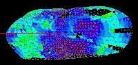
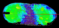
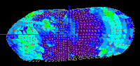
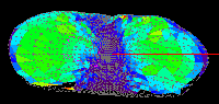
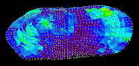
Note that, in the following pictures, the colors on the different plates represent the best emission angle found for that plate. Purple corresponds to zero while red corresponds to 90, and green is in the middle. Since our main priority is low emission angle data, the closer to purple a model is, the better. (Note that black regions are ones for which no pictures were taken.)
| Lattitude Scan |
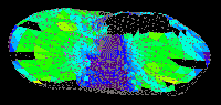
|
|
| 1 by 2 Longitude Scan |
|
|
| 1 by 3 Longitude Scan |
|
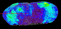
|
| 1 by 4 Longitude Scan |
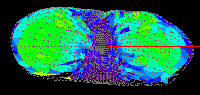
|
|
A comparison of the 4 types of orbits revealed that the a by 3 was probably the best; 1 by 4 had no significant advantages, and was difficult for the spacecraf to carry out.
(Emily Peters and Jessica Edmonds, 7-29-99)