
| Encounters | Processing Status | Mission Bulletins | Mission Image Archive | References | Related Links | Mercury Gazetteer | MESSENGER Mission |
| Earth-Moon Departure | Venus | Mercury Encounter I | Mercury Encounter II | Mercury Encounter III |
Earth-Moon Departure
Mariner 10 was launched on November 3, 1973, 12:45 am PST, from Cape Canaveral on an Atlas/Centaur rocket (a reconditioned Intercontinental Ballistic Missile - ICBM).
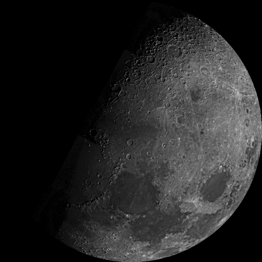
Within 12 hours of launch the twin cameras were turned on and several hundred pictures of both the Earth and the Moon were acquired over the following days. Twenty images acquired looking down on the Moon's North Pole have been mosaicked (below) as part of the current calibration effort.
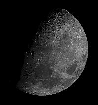 In this unusual view eastern Mare Frigoris is near the center of the disc,
while Mare Crisium is the large circular feature near the lower right limb.
The heavily cratered region shown in the top of the mosaic shows portions
of the Moon not seen from the Earth. Click here
for a larger image.
In this unusual view eastern Mare Frigoris is near the center of the disc,
while Mare Crisium is the large circular feature near the lower right limb.
The heavily cratered region shown in the top of the mosaic shows portions
of the Moon not seen from the Earth. Click here
for a larger image.
This mosaic is composed of 22 frames acquired in orange (15), clear (4), UV (2), and UV-polarized (1) wavelengths by the Mariner 10 Spacecraft. [Robinson et al., 1992; Robinson and Edwards, 1995].
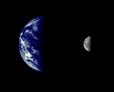
 The Earth and Moon were imaged by Mariner 10 from 2.6 million km while
completing the first ever Earth-Moon encounter by a spacecraft capable of
returning high resolution digital color image data. These images have been
combined at right to illustrate the relative sizes of the two bodies. From
this particular viewpoint the Earth appears to be a water planet!
The Earth and Moon were imaged by Mariner 10 from 2.6 million km while
completing the first ever Earth-Moon encounter by a spacecraft capable of
returning high resolution digital color image data. These images have been
combined at right to illustrate the relative sizes of the two bodies. From
this particular viewpoint the Earth appears to be a water planet!
Medium version of this image (17,591 bytes)
Large version of this image (43,750 bytes)
Venus
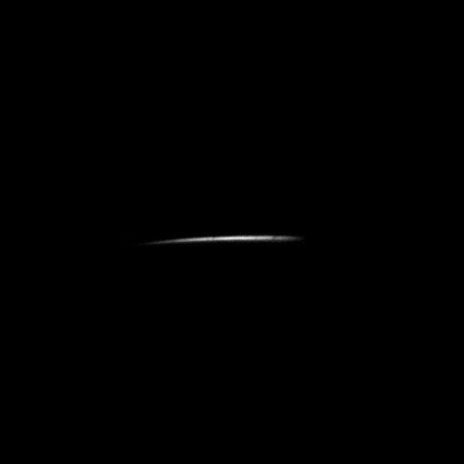
On February 5th Venus first came into view and Mariner 10 acquired this dramatic image (Feb 5 1974, 9:49 AM PDT) of the lighted cusp of Venus' North Pole. Click here for a larger image.
Over the next week, Mariner 10 acquired over 4000 images of Venus showing the capabilities of the imaging systems and revealing for the first time a high resolution look at the cloud-shrouded planet.
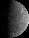
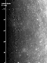
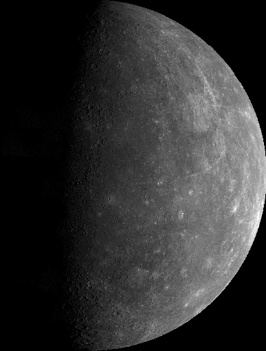
Mercury Encounter I
Mariner 10's first image of Mercury was acquired on March 24, 1974, from a distance of 3,340,000 miles (5,380,000 km). Mariner 10's trajectory brought its closest approach behind the lighted hemisphere of Mercury in order to acquire important measurements with other instruments (March 29). Thus, the images were acquired in two steps, an inbound leg (images acquired before passing into Mercury's shadow), and an outbound leg (after exiting from Mercury's shadow).
More than 2300 useful images of Mercury were taken, both moderate resolution (3-20 km/pixel) color and high resolution (better than 1 km/pixel) black and white coverage. For an animated sequence of the whole encounter

|
|

|
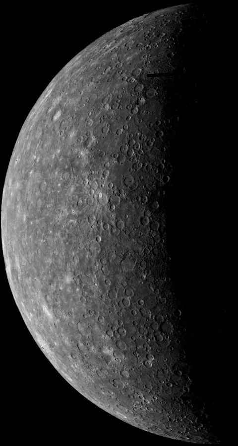
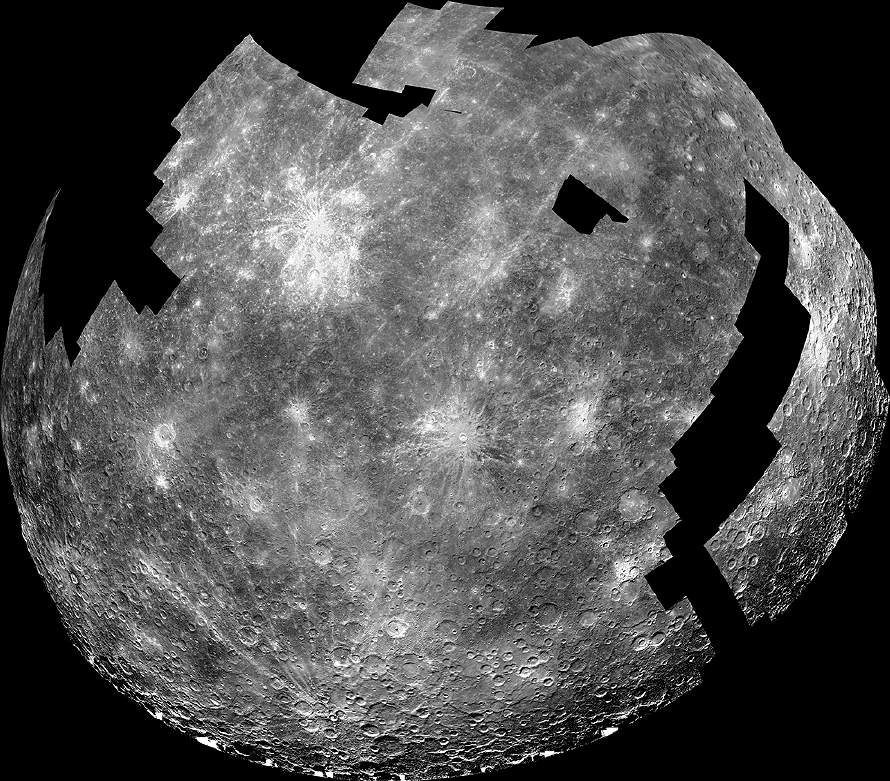
Incoming hemisphere Mosaic of over 50 images acquired before Mariner 10 flew behind Mercury during the 1st Encounter (March 29, 1974).
Medium version of this image (123,291 bytes) |
|
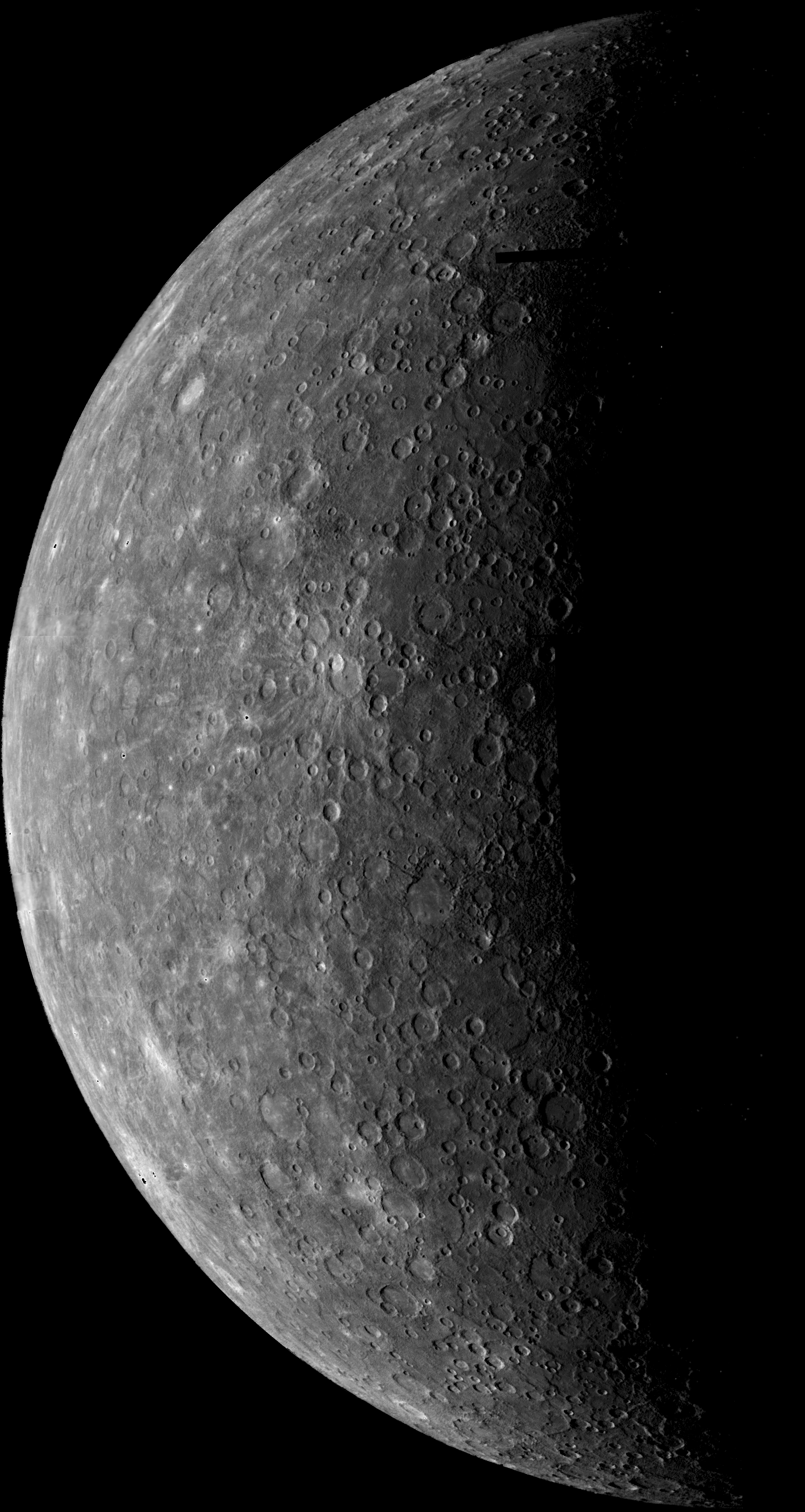
Outgoing hemisphere Over 140 images were used to compose this mosaic, the original images had resolutions over a range of .4 to 2.8 km/pixel. The large version here is resampled at 4 km pixel.
Medium version of this image (58,000 bytes) |
|
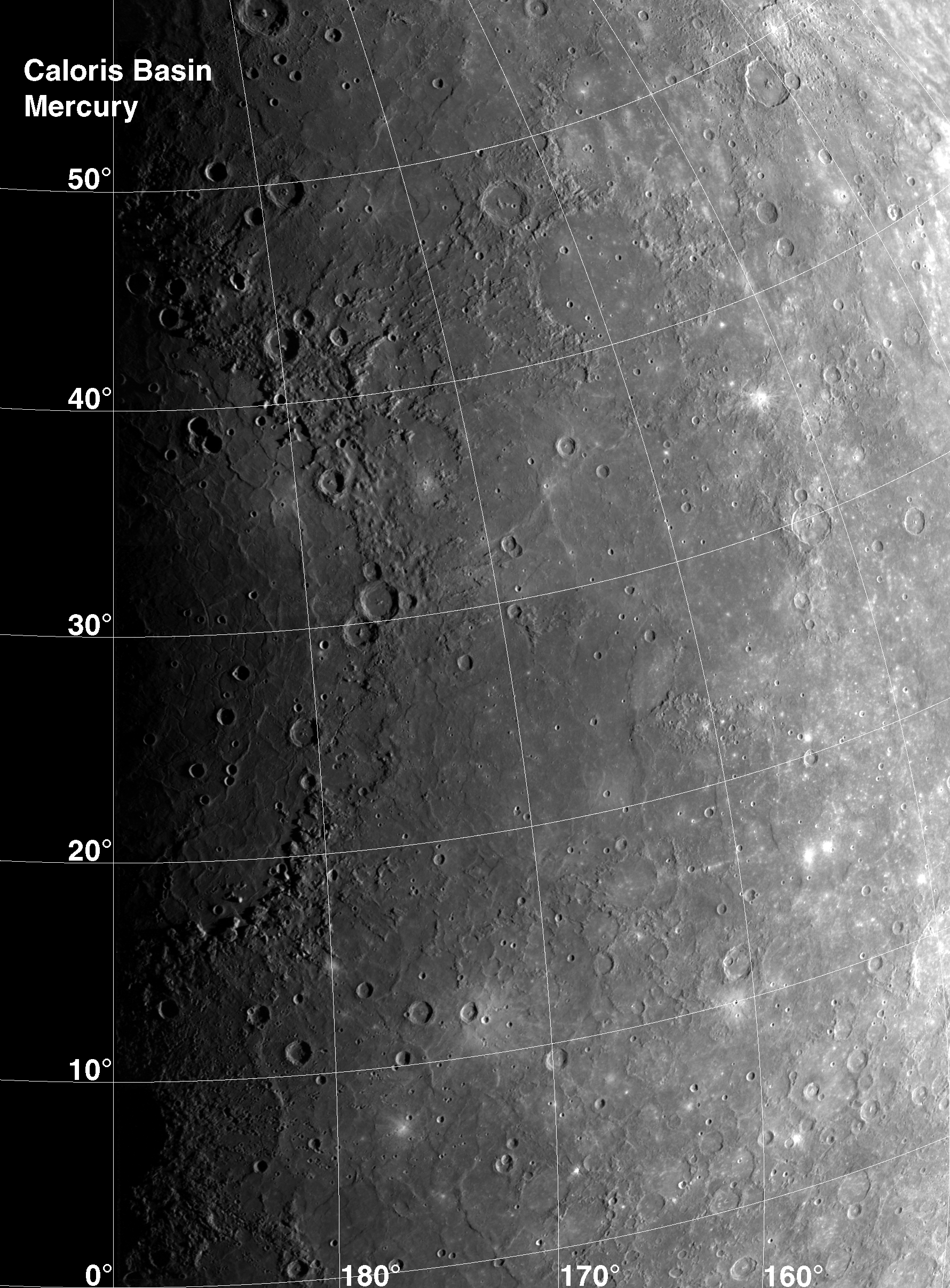
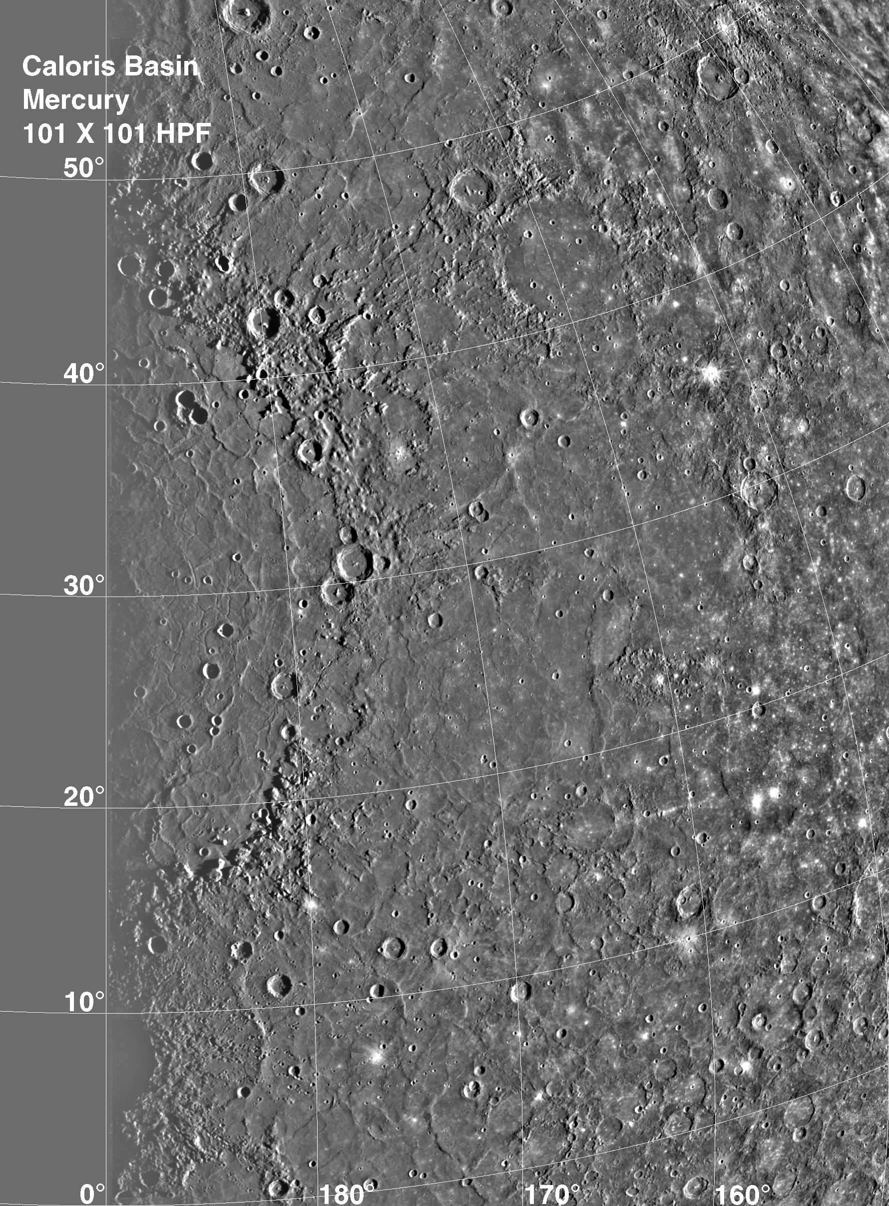
Caloris Basin A 1 km per pixel mosaic of the spectacular Caloris Basin. The Caloris Basin is one of the largest basins in the solar system, its diameter exceeds 1300 km and is in many ways similar to the great Imbrium basin on the Moon (diameter >1100 km). An excellent discussion of planetary impact basins can be found in "The Geology of Multi-Ring Impact Basins" by Paul D. Spudis. To enhance landforms a high pass Filtered of this mosaic is also available.
Normal version of this image (3,914,229 bytes) |
The current calibration and mosaicking effort have led to substantial improvements in the Mariner 10 color image data. Analysis of these exciting new mosaics is underway and some preliminary results follow.
|
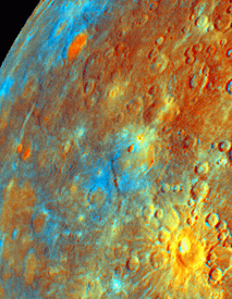
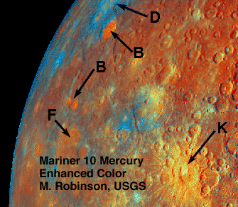
Incoming Hemishpere Enhanced Color This color composite was formed to especially highlight differences in opaque minerals (such as ilmenite), Iron content, and soil maturity (see Robinson and Lucey, Science, 10 Jan 1997, Vol 275, for details) or NASA Planetary Science Research Discoveries article, January 1997. |
|
Incoming Hemisphere Enhanced Color - Annotated
|
Very little is known about the regolith or the bulk composition of the mercurian crust [c.f. Chapman, 1988]. Color images exist for only half of Mercury's surface [Danielson et al., 1975], and its close proximity to the Sun makes terrestrial observations problematical at best [Vilas, 1988].
From Earth-based spectral measurements it is proposed that Mercury has no gross hemispherical mineralogical differences and that a weak Fe absorption feature might exist near 0.9 µm [Vilas, 1988]. Due to Mercury's high bulk density a high bulk Fe content has been assumed [c.f. Chapman, 1988]. However, there is no direct evidence of a high Fe content in the crust.
Earlier analysis of Mariner 10 orange and UV images led to the startling inference that Mercury's regolith, and thus crust, may actually be deficient in Fe2+ and Ti4+ relative to the Moon [c.f. Rava and Hapke, 1987]. However, this apparent contradiction may not be real.
An average impact event on Mercury should produce about twice the melt as a similar event on the Moon [Cintala, 1992]. Agglutinate glasses formed from such impacts alter the spectral properties of the regolith [Adams and Jones, 1970; Conel and Nash, 1970; Adams and McCord, 1973; Hapke, 1973; Charette et al., 1976]. Increased agglutinate content results in reduced overall spectral contrast and a general reddening of the visible slope. Cintala [1992] has proposed that abundant agglutinates in the mercurian regolith are masking the 0.9 µm Fe absorption feature, thus the regolith and crust may not be deficient in Fe.
Many questions such as this can be addressed with digital calibrated Mariner 10 image data. We are extending the original Mariner 10 color and albedo analyses [Hapke et al., 1980; Rava and Hapke, 1987] by refining the calibration for all four bandpasses (UV-polarized, UV, blue, orange), as well as the broadband visible filter [Robinson et al., 1992; Robinson and Edwards, 1995], and by creating a high resolution (1 km) albedo map for all portions of Mercury imaged by Mariner 10.
The color data will allow for mapping of the distribution and abundance of opaque minerals, such as ilmenite (titanium bearing). In particular these color and albedo data will be compared to the Moon so that basin ejecta deposits, intercrater plains, smooth plains, and heavily cratered terrain can be examined (see also NASA Planetary Science Research Discoveries article, Mercury Unveiled (January 1997)).
Mercury Encounter II
After passing Mercury the first time and making a trip around the Sun, Mariner 10 again flew by Mercury on September 21 at 1:59 PM PDT. This encounter brought the spacecraft in front of Mercury in the southern hemisphere.
Despite failure of the onboard tape recorder, over 750 useful images of Mercury were acquired that greatly enhance the earlier data. A subset of these images is currently being mosaicked into a southern hemisphere view of the planet that bridges the coverage between the incoming and outgoing views of the first encounter.

|
Nearly complete mosaic of the southern hemisphere of Mercury from over
150 images acquired during the second encounter (reduced resolution).
The gores (or holes in the mosaic) will be filled with images acquired
during the first and second encounter. Click here for a larger image. |

|
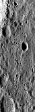
Hero Rupes, the large scarp visible running across the bottom of the
image, is thought to thought to have been formed by global tectonic
forces, possibly due to shrinkage of the planet as it cooled. Mariner
10 was looking obliquely across Mercury's southern hemisphere when it
acquired this dramatic shot near the beginning of its southern
hemisphere pass (Frame 166618 original image acquired at ~670
m/pixel). Click here for a larger image. |

|
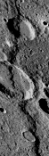
Much of Mercury looks like the lunar highlands, a scene carved by
billions of years of impact craters. This image was taken when Mariner
10 was near its closest approach to the planet during the scond
encounter, about 50,000 km. This image is found near the center of the
area not imaged during the first encounter. These images tie together
the incoming and outgoing mosaics of the first encounter. (Frame 166724
original image acquired at ~440 m/pixel). Click here for a larger image. |

|
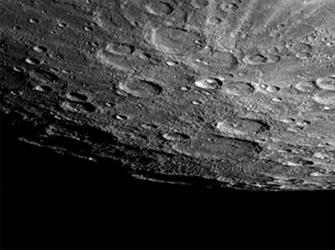
In this frame south is down, the south pole is located on the right
hand edge of the large crater that has only its rim sticking up into
the light (Chao Meng Fu crater). When this frame was acquired Mariner
10 was about 83,000km from Mercury completing the southern hemisphere
mosaic (Frame 166902), original image acquired at ~750 m/pixel. |
Mercury Encounter III
As an added bonus, a limping spacecraft was coaxed into a third and final encounter with Mercury in March of 1975. Due to several problems with the aging spacecraft, only ~450 useful images of the planet were acquired, though many are at significantly higher resolution than previous encounters.
|
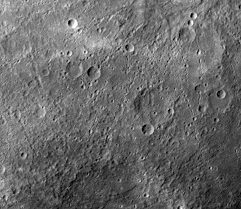
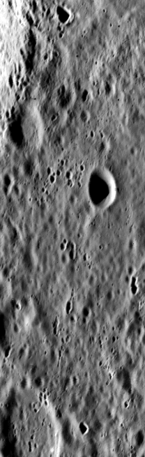
This is one of the highest resolution images of Mercury acquired by Mariner 10: Frame 528922, ~90 m/pixel. Click here for a larger image.
In this high resolution image the sun is low to the horizon thus
enhancing topographic features with prominent shadows. As can be seen
here, the surface of Mercury is heavily cratered similar to the
Moon. |
|
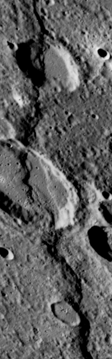
The prominent scarp that snakes up the image was named Discovery Rupes. Like Hero Rupes this feature is thought to have been formed as the planet compressed, possibly caused by cooling of the planet.
Click here for an image map of the
region (Reduced resolution - 138 Kbytes) The vertical (tall narrow) format of the second encounter images resulted from problems with the tape recorder and transmitter on the spacecraft. Only the middle quarter of each frame could be sent back. Frame 528884, ~250 m/pixel. Click here for a larger image. |